 RSS
RSS
Fall Hiking at Berlin Mountain
It’s been a hot summer and, unfortunately, in the meantime I’ve become rather physically lazy. While last year, I was hiking, indoor rock climbing, or swimming as much as I could, this year I’ve been more pressed for cash and time so my free time I’ve tended to do anything except be active.
So, I was kind of excited when my dad invited me on an organized hike that he read about in The Eastwick Press, the community paper for eastern Rensselaer County.
The Rensselaer Land Trust and Mohawk-Hudson Chapter of the Appalachian Mountain Club co-sponsored and co-led the hike which started at the Petersburgh Pass on Route 2. When reading the summary of the hike, I knew too well some of the steep inclines it talked about.
I’d done part of the hike before, but only the beginning of it, and remembered that in the first quarter-mile there was a difficult section with loose sediment, rocks, and very few resting areas. Along with this, the hike, which attracted about 10 people, was the weekend after the heavy rain storms so the leaves were down and they were wet.
But, there is a pro and con to having this steep section in the beginning. At least you get it over with, but then you have to anticipate descending it on the way back. And, as many hikers know, going down can be as hard or harder than going up sometimes.
Still, the rest of the hike was not bad at all. Surrounded by all specimens of trees and plant life – hemlocks, blueberries, wild flowers – we went onwards on the trail that is estimated at around 6 miles round trip.
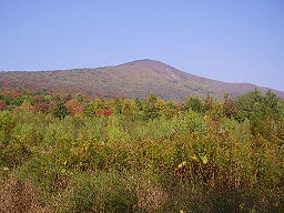
It follows the Taconic Trail and crosses Berlin Pass, where the Albany Road ran in the 1700s. It is more of a rolling hike since there are small inclines and declines, until you reach the end with a steady hike up to the 2,798 foot summit of Berlin Mountain.
As the tallest point in Rensselaer County, there were nice vistas of the Berkshires and Mt. Greylock, easily detectable due to the towers on its top.
The way back wasn’t too bad, we just had to avoid stepping in the horse poop. My dad and I are still not sure how a horse got up that first steep part, unless they took the trail that leads to Petersburgh.
This was my first organized hike, so it was nice having rest breaks and meeting other people in the area. As it turned out, many of the hikers followed the six degrees of separation with my family since there were a few Sage professors who taught my sister and one who knew a former good friend of my dad’s.
My favorite part, other than the summit, was this nice mossy and grassy spot near the beginning where we rested on the way back. Laying down on that moss in the sun hit the spot.
Those interested in doing future hikes can contact Nike Conrad at 279-1963 or nbconrad@msn.com.
So, I was kind of excited when my dad invited me on an organized hike that he read about in The Eastwick Press, the community paper for eastern Rensselaer County.
The Rensselaer Land Trust and Mohawk-Hudson Chapter of the Appalachian Mountain Club co-sponsored and co-led the hike which started at the Petersburgh Pass on Route 2. When reading the summary of the hike, I knew too well some of the steep inclines it talked about.
I’d done part of the hike before, but only the beginning of it, and remembered that in the first quarter-mile there was a difficult section with loose sediment, rocks, and very few resting areas. Along with this, the hike, which attracted about 10 people, was the weekend after the heavy rain storms so the leaves were down and they were wet.
But, there is a pro and con to having this steep section in the beginning. At least you get it over with, but then you have to anticipate descending it on the way back. And, as many hikers know, going down can be as hard or harder than going up sometimes.
Still, the rest of the hike was not bad at all. Surrounded by all specimens of trees and plant life – hemlocks, blueberries, wild flowers – we went onwards on the trail that is estimated at around 6 miles round trip.
It follows the Taconic Trail and crosses Berlin Pass, where the Albany Road ran in the 1700s. It is more of a rolling hike since there are small inclines and declines, until you reach the end with a steady hike up to the 2,798 foot summit of Berlin Mountain.
As the tallest point in Rensselaer County, there were nice vistas of the Berkshires and Mt. Greylock, easily detectable due to the towers on its top.
The way back wasn’t too bad, we just had to avoid stepping in the horse poop. My dad and I are still not sure how a horse got up that first steep part, unless they took the trail that leads to Petersburgh.
This was my first organized hike, so it was nice having rest breaks and meeting other people in the area. As it turned out, many of the hikers followed the six degrees of separation with my family since there were a few Sage professors who taught my sister and one who knew a former good friend of my dad’s.
My favorite part, other than the summit, was this nice mossy and grassy spot near the beginning where we rested on the way back. Laying down on that moss in the sun hit the spot.
Those interested in doing future hikes can contact Nike Conrad at 279-1963 or nbconrad@msn.com.
posted by Danielle Sanzone at
2:26 PM
![]()

0 Comments:
Post a Comment
Subscribe to Post Comments [Atom]
<< Home